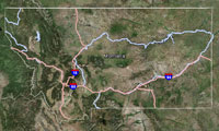
Bighorn Lake is a small (15 acres) glacial cirque lake located along the Continental Divide approximately 1.4 west of Caribou Peak. The lake lies with in the Scapegoat Wilderness, Helena National Forest (USFS Lincoln Ranger District) at 7,492 ft elevation in Landers Fork drainage, tributary to the upper Blackfoot River basin.
 Bighorn Lake
Looking down on Bighorn Lake
| Size: | 14.3802 acres |
| Elevation: | 7596.48 ft |
| Directions: | Access to Bighorn Lake can be obtained by taking Hwy 200 east from Lincoln, MT approximately 6.2 miles to the Copper Creek Rd. Follow the Copper Creek Rd. approximately 10.2 miles to the Indian Meadows Trailhead. From the trailhead either hike or pack in on horses along USFS Trail #481 (Main Line Pack Trail) 4.0 miles to USFS Trail #424. These trails are in great condition with moderate difficultly. Follow USFS Trail #424, 0.9 miles to the northeast side of Heart Lake to it’s junction with USFS trail #478. From Heart Lake, USFS trail #478 travels directly north for 1.6 miles through a series of relatively steep difficult switchbacks before it connects into USFS Trail #438. USFS Trail #438 (Landers Fork Pack Trail) travels north paralleling Bighorn Creek for 2.4 miles to it’s junction with USFS Trail #441 that continues following Bighorn Creek northeast another 6.5 miles where it intercepts USFS Trail #440 along the top of the continental divide. The last 1.5 miles of USFS Trail #441 is steep difficult switchbacks. Once on top of the continental divide follow USFS Trail #440 south 2.0 miles to a short spur trail (USFS Trail #442) that leads into Bighorn Lake approximately 0.4 miles distance. Overall trail conditions are good. |
| Status of the Fishery: | |
| Township/Range/Section: | 17N 08W 34 |
| Latitude/Longitude: | 47.18843 -112.60472 |
| FWP Region: | Region 2 |
| County: | |
| Fishing District: | Western |
| Type: | MTNLAKE |

Click on rows to select them for use in other tabs.
| Waterbody | Section | Field Form Type | Date | Purpose | Species |
|---|
To see this data, first select one or more rows from the Collection Info tab.
For Comparative analysis all Length Units are millimeters : all Weights are grams
| Species | Count | Avg | StdDev | Min | Max | AvgWgt | StdDevWgt | MinWeight | S/L | Sects | Surveys | Waterbody |
|---|
To see this data, first select one or more rows from the Collection Info tab.
For Comparative analysis all Length Units are millimeters : all Weights are grams
| Waterbody | Section | Species | Count | AveLength | StdDevLength | MinLength | MaxLength | AveWeight | StdDevWeight | MinWeight | MaxWeight |
|---|
To see this data, first select one or more rows from the Collection Info tab.
For Comparative analysis all Length Units are millimeters : all Weights are grams
| Waterbody | Year | Section | Species | Count | AveLength | StdDevLength | MinLength | MaxLength | AveWeight | StdDevWeight | MinWeight | MaxWeight |
|---|
To see this data, first select one or more rows from the Collection Info tab.
This is a preview, all fields will be visible by selecting a download option. For Comparative analysis all Length Units are millimeters : all Weights are grams.
| Year | Species Abbrv | Length | Weight | M/C | Count | Sex | Mort | Hook Scar | Disease | Scales | Otolith | Fin Clip | Tag | Comment | Genetics | Age | Stomach | Intercept | Slope | Gear | Equipment | Trip | Date | Pass/Run | Water | Section | Lat/Down | Lon/Down | Lat/Up | Lon/Up | Agency | Start Depth | End Depth |
|---|
View the latest Montana Fishing Regulations.
No Gauging Stations found.
There is no fish consumption advisory for this waterbody.