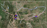
Lower Bonanza Lake is a small (8.7 acres), remote glacial cirque lake located near the Idaho border in the Cedar Creek drainage at 6,253 ft elevation. The lake lies on the Lolo National Forest (Superior Ranger District).
| Size: | 8.7 acres |
| Elevation: | 6253 ft |
| Directions: | Access to Lower Bonanza Lake can easily be obtained by either of two routes. One is by taking USFS Road #320 (Cedar Creek Road) from Superior, Montana for approximately 19 miles. Turn right on USFS Road #7763 near the Oregon Lakes trailhead. Take Road #7763 north 1.7 miles to USFS Trail #616. Two miles up the trail; you will find Lower Bonanza Lake. The trail is moderately difficult with some steep stretches. The other option is to continue on USFS Road #320 to the Stateline National Recreation Trail (#738) and hike 1.5 miles northwest to Trail #616, then hike 0.8 miles down Trail #616 to the lake. This route will have the advantage of being well traveled, and is relatively flat for the first two-thirds of the hike. |
| Status of the Fishery: | |
| Township/Range/Section: | 15N 28W 3 |
| Latitude/Longitude: | 47.08689 -115.13193 |
| FWP Region: | Region 2 |
| County: | |
| Fishing District: | Western |

Click on rows to select them for use in other tabs.
| Waterbody | Section | Field Form Type | Date | Purpose | Species |
|---|
To see this data, first select one or more rows from the Collection Info tab.
For Comparative analysis all Length Units are millimeters : all Weights are grams
| Species | Count | Avg | StdDev | Min | Max | AvgWgt | StdDevWgt | MinWeight | S/L | Sects | Surveys | Waterbody |
|---|
To see this data, first select one or more rows from the Collection Info tab.
For Comparative analysis all Length Units are millimeters : all Weights are grams
| Waterbody | Section | Species | Count | AveLength | StdDevLength | MinLength | MaxLength | AveWeight | StdDevWeight | MinWeight | MaxWeight |
|---|
To see this data, first select one or more rows from the Collection Info tab.
For Comparative analysis all Length Units are millimeters : all Weights are grams
| Waterbody | Year | Section | Species | Count | AveLength | StdDevLength | MinLength | MaxLength | AveWeight | StdDevWeight | MinWeight | MaxWeight |
|---|
To see this data, first select one or more rows from the Collection Info tab.
This is a preview, all fields will be visible by selecting a download option. For Comparative analysis all Length Units are millimeters : all Weights are grams.
| Year | Species Abbrv | Length | Weight | M/C | Count | Sex | Mort | Hook Scar | Disease | Scales | Otolith | Fin Clip | Tag | Comment | Genetics | Age | Stomach | Intercept | Slope | Gear | Equipment | Trip | Date | Pass/Run | Water | Section | Lat/Down | Lon/Down | Lat/Up | Lon/Up | Agency | Start Depth | End Depth |
|---|
View the latest Montana Fishing Regulations.
No Gauging Stations found.
There is no fish consumption advisory for this waterbody.